

Nutrient neutrality and local plans – a dilemma to be resolved

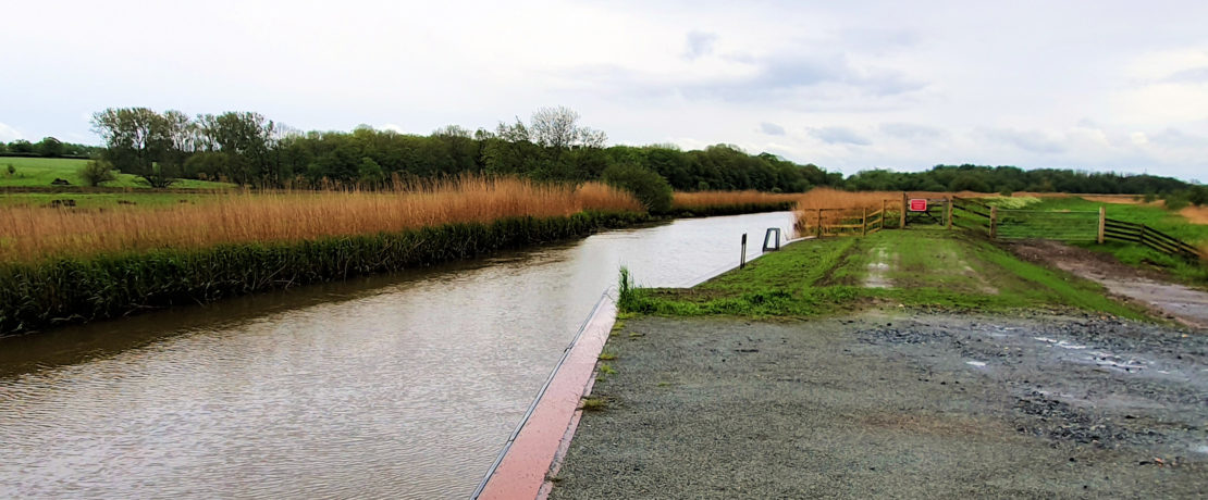
Nearly all our rivers are in an unfavourable ecological condition and damaging the wildlife who are dependent on them. Sites of international importance are not exempt from the pollution, including in Norfolk the Broads and River Wensum.
This has come to a head with Natural England using the Habitats Regulations to put constraints on planning authorities such that unless they can establish with confidence that a policy or planning application would not make the situation any worse than it is already, they should not proceed. This in technical terms means it must be ‘nutrient neutral’, and not add to the nitrate and phosphate levels. This applies to all new housing development, overnight stays and some other development in the catchment area of the Broads and River Wensum. That embraces a very large area which includes many parts of Broadland, Norwich, South Norfolk and North Norfolk Councils in particular, but other councils are involved; Great Yarmouth, King’s Lynn and West Norfolk and the Broads Authority.
A brief has been prepared for a programme of work which is planned to be completed by February 2023. This is a national directive, and there are another nine areas affected in England, the biggest two being in the north and south, with the area ln Norfolk third in area size. For the Councils affected there is potentially a huge impact on the planning system, and in particular the progression of the delivery of Local Plans. Further all planning applications, including those with an overnight stay, are effectively frozen and on hold.
There will be a programme of work with proposed short, medium and long-term solutions. Given the critical situation the emphasis will be on the short term, many will be ‘sticking plaster’, and some of these will be mitigations with dubious validity. Years of neglect and abuse of our rivers has led us into a crisis of our own making. It will disrupt the progression and the delivery of carefully worked out plans which seek to meet growth targets while minimising the impact on the countryside and natural environment.
What is at stake at the most fundamental level is how we treat our land and water, and ask is it sensible to continue a pathway to the detriment of not just our wildlife but also people. The answer is certainly not, but we need to convince the Government.
The pollution of our rivers and wetlands
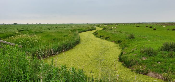 Our natural environment has been degraded over the past five decades, the result of intensive farming and arable run-off entering our river systems, and the lax treatment of sewage and discharge into our rivers, either direct or a connected water body. The outcome from both sources is that our rivers and waterways are continually being polluted, but the dominant one is the nutrients, nitrate and phosphate – think as fertiliser. Excessive levels cause the rapid growth of plants such as algae which changes the ecology by deoxygenation of the water, and less sunlight with blanket coverage. The most obvious impact is the presence of dead fish, but all wildlife is affected.
The pollution from surface arable sources has been reduced in recent years by the use of grass margins adjacent to ditches, tributaries and the main river, but this is still a work in progress, especially at the headwaters of the river, and with silt also, with source to sea issues. There are also major problems with surface water percolating through the soil into the aquifer.
Both sources are a problem for water companies, who abstract their ‘raw’ water supply either from a river, or by borehole from the aquifer, and it has been increasingly ‘challenging’ to process to a potable standard, with legal limits for nitrates and pesticides an issue, the latter at miniscule level. Water companies however have greatly underinvested (by some 25%) in their sewage treatment plants and incoming pipe network.
Alongside this there has been a growing abuse of the legislation which allows in exceptional conditions the use of a storm overflow in the event of a heavy rain to discharge raw sewage into rivers or direct into the sea. Otherwise, the sewage manholes would be dislodged and flood an area. Storm overflows have been used routinely to compensate for a lack of plant capacity, some for long continuous periods of time.
In the past two years Thames Water has been fined £126 million, just for falsifying records, and yet to make compensation for the pollution, and Southern Water £90m.
Much of the problem lies at the door of successive Governments.
There are strong pressures to keep the price of water (and food) down. There is also a Government requirement that water companies must have a 25 year long-term plan to source additional water resource and also the infrastructure in place at the right time and location to meet the projected increases in population and housing numbers across a region. The investment need has to be justified in great detail to the Regulator Ofwat, and then capped for the first five years of a 25-year plan.
Investment in sewage treatment and disposal has taken the hit in the squeeze between Government and Regulator keeping water costs down while at the same time growth is the priority. Dumping sewage was seen as the low-profile way to overcome this mismatch (and keep water company profit levels both high and sustained). More information is now available on the number and length of times of spills, but the Government has denied the request that the “event duration monitors”, which do not measure the volume of sewage poured into waterways, needed to relate with the impact on river ecology. The Government agrees with the water companies that this is difficult and expensive to do.
Some water companies now genuinely accept that the current situation is not acceptable, and we would include Anglian Water in this category. Some are becoming more transparent about their operations and even looking to rise to the challenge of bringing our water bodies to a good ecological and healthy condition. However, this requires Government to accept that there needs to be much more investment over a number of years, and perhaps have a re-think on what kind and how much growth we press on our most fundamental assets, we repeat, water and soil.
The planning system
In 2012, the Government made a fundamental change in the planning system, bringing in “a presumption in favour of development”. In effect, the onus was on a Council to show that an application was not sustainable if they were to refuse.
The decision-making process is based on the Council’s Local Plan, which looks to the future 25 years ahead, with a vision of what the district would be like and the policies to achieve their aims.
A key part is the spatial strategy, how and where new development should be located. The Local Plan has to be developed within national guidance, the National Planning Policy Framework (NPPF). This is a lengthy process, with much data to collect and analyse, and from this evidence base decide on the best approaches for plan-making and decision-making. The draft Plan then goes to a public consultation stage, and after some modifications, to a Public Inquiry for examination by a Planning Inspector who decides whether the Local Plan is ‘sound’ or not. If so, it is then formally adopted. If not, the Inspector can indicate the changes needed to make it sound.
Over the past 5-10 years, the NPPF has seen a number of revisions with an increasing focus on growth in general and housing in particular.
The planning system is a convenient scapegoat for all that goes wrong with the planned delivery of new housing, although recently big developers have seen some criticism (‘big’ are just about the only ones left). Councils must have rolling five-year plans on housing delivery on allocated land as shown in the Local Plan. This operates on three five-year periods, with clear evidence that the land supply for the coming five years is ‘all ready to go’ for developers to start building. If not, developers are freer to build on land that has not been allocated, if it is deemed to be ‘sustainable’. Further if the targets for the delivery of completed housing are not met over a period of time, then a ‘buffer’ of an additional 20% on the target, on the theory that this will resolve the situation. In practice the extra land the Council has to allocate opens the door to cherry-picking of the best and most profitable sites by developers.
So the concerns that CPRE Norfolk have, and also councils, that some developers will argue that Councils no longer have a five-year land supply, due to the current freezing of planning applications due to the nutrient neutrality issue, and they can now apply to build on land which has not been allocated, and for good reason because it has been shown that there are better options.
The highest numbers of housing has been assigned to the Greater Norwich Area: Broadland, South Norfolk and Norwich, with South Norfolk in particular keen on some dispersal strategy options into the open countryside. CPRE Norfolk campaigns to avoid this and looks to have a concentration option rather than sprawl, with the housing being focussed in and around Norwich, and particularly on brownfield sites. Two major ones are an appropriate redevelopment at Anglia Square, and also more recently the former Colman’s Mustard and Britvic site. To this we can perhaps also add housing coming from ‘’windfall’ sites in Norwich and larger market towns; this because of some reduction in the amount of required office space and some retail outlets.
North Norfolk faces a difficult situation in that most of their land area comes under the Nutrient Neutrality directive, and that which is not is mainly within the AONB – a Protected Landscape, and developers would be keen to see more opportunities.
What we can and must do
 There must be a long-term strategy for the restoration of our natural environment. At present there is a near complete absence.
This shows in the 2021 document of the Norfolk Strategic Planning Forum (or Framework, but both under the acronym NSPF). This was initially represented by senior councillors, but now senior planning officers from all councils. The NSPF works under the duty to co-operate, and in practice this means also coming to a broad agreement on major planning issues and policies across the county. As would be expected this reflects the policies of the NPPF and the priorities of the existing Government. Coming from national level is the concept of obtaining environmental gain as a spin-off from growth. This is not working for the natural environment, and never will. It needs a long-term strategy, well-funded, and a partnership encompassing the Environment Agency, Natural England, a range of environmental NGOs, water companies, and most importantly farmers and landowners.
Pre-2010, some Councils took the advice of the Norfolk Wildlife Trust and acknowledged that the importance of connectivity between habitats and the ecological network provided by our river systems was critical to the long-term survival of our wildlife. Furthermore, the chemistry of the rivers, influenced by the chalk strata underlying them, had a special and unique ecology of international importance, with the bulk of them being in southeast of England.
From there was a giant step backwards. Ecological networks were eased out to be replaced by Green Infrastructure (GI). GI happens where there is a major expansion of new housing around the larger market towns and provided by a levy from the developer, who delivers green spaces. While having some benefits to residents, and in spite of claims of creating heathland or an ancient meadow, the biodiversity value is quite likely less than an arable field with some hedges.
GI became the flavour of the decade, and following that, now fully burgeoning, we have Biodiversity Net Gain (BNG). BNG is a very complex pseudo-science that only some developers and consultants will understand, plus a few Planning Inspectors. You have to be able to monetise the value of nature, how to work out 10% in mitigation to be applied somewhere, and be able to trade in the BNG market.
However, the value of wildlife corridors was brought to attention again by the Landscapes Review and the Final Report released in October 2019. This was the flagship project promised in the 25-Year Environment Plan, to recover the UK being one of the most nature-depleted countries in the world. The Report highlighted the importance of the Environmental Land Management Scheme, and Nature Recovery Networks, and we also have Local Nature Recovery Strategies.
The Government reacted with a consultation on their response to the Review at the beginning of this year, 2022; this is supportive but had lost much time.
CPRE Norfolk responded with proposals that we had been pursuing for two years, primarily a Nature Recovery Network from the North Norfolk Coast overland to the East Coast.
This connection is formed by the dual wildlife corridors provided by the Rivers Glaven and Bure, and Stiffkey and Wensum/Yare, both of which separately cross the Broads.
The gateway from the North Norfolk Coast is the Blakeney Lagoon; from the East it is Breydon Water. This ecological network connects many high designated sites of conservation with each other and the wider countryside. In an arable dominated landscape, any Intensive pesticide use results in the loss of all insects and the collapse of ecosystems. River systems provide a buffer with floodplain meadows, areas of wet and ‘dry’ woodland, and grassland, providing a wide and continuous corridor for wildlife.
These four chalk rivers are unusual in that their sources are relatively close to each other, with Glaven and Stiffkey flowing north and through the Blakeney Lagoon into the sea. The Bure and Wensum/Bure flow east and across the Broads, enter Breydon Water and the sea on the east coast. What nature has offered can be enhanced by improving the connectivity between the four rivers at their headwaters. This by the conversion of arable land to grassland, scrub, more hedgerows and tree planting, which would see retention of rainfall.
There would be multiple benefits: better connectivity in the ecological network; less arable run-off; carbon capture by the planting; flood risk reduction by the hold-up of rainwater. This would embrace a considerable area to be seen as a Local Nature Recovery Strategy.
For the Nature Recovery Network this would sit alongside a strategy of further restoration work on the rivers downstream as they make their way to the sea, and keep them in good ecological condition.
The Broads will never be kept in good condition while they act as a receptor and sump to silt, nutrients and agrichemicals carried by the Wensum (and Bure) which keep polluting them. The rivers must be kept clean if the Broads are to flourish. The Wensum is a SAC river and the STWs are required to have phosphate strippers to lower phosphate levels, being rate-determining for algae growth.
Likewise, the Bure as flowing through the Broads SAC, but this process is expensive and only partially successful.
The Natural England letter states under the heading of ‘Situations where Nutrient Neutrality may not be an appropriate Mitigation Measure: lake or wetland sites and particularly those with long residence times or which have a limited or no outflow. For these types of sites nutrients will accumulate over time and therefore they are particularly vulnerable to even small increases in nutrients which will further hinder restoration’.
Give Nature a Chance.